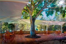
Click on the title and you'll see what Colleges Crossing looked like in the early morning of the 5th June 2010.
Its in sharp contrast to what has happened to our park in the last couple of weeks.
It will take a massive effort on behalf of the Ipswich City Council to rebuild and replant the park to anything like it was.
The flood damage has levelled just about every tree and washed away the landscape and gardens.
The cafe was removed - as it was designed for - on the 10th January, just in time as the flood front made its way downstream.
This is the slot that the cafe rested in before and after:
The bridge at Colleges Crossing was a hive of activity today - as the clean up of the roads got underway. But, the river is still flowing over the bridge preventing engineers carrying out their inspections.
The road is not only a link to the Colleges Crossing Recreation Reserve, but is also an important connection for people accessing schools in the Ipswich area. With the weir bridge to be repaired - it will be the only link. Most of the school buses are on the Ipswich side of the river - and a round trip via the Centenary Motorway is 100 kilometres. School starts next week.
After taking a nostalgic look at the June pictures - it will be interesting to see how long it will take to repair and the park - and what it will look like. Fingers crossed.
Showing posts with label centenary highway. Show all posts
Saturday, January 22, 2011
Monday, January 10, 2011
This is real coffee To-Go
Talk about take-away coffee- our cafe Colleges by the River was today lifted onto a low-loader and taken to higher ground.
Its expected that the Brisbane River height will hit 14m at the Colleges Crossing Park - and there's a spectacular amount of water washing through the area at the moment. Its currently 11.66m in the park - and the Wivenhoe dam is due to dump a huge amount of water on top of that. The water is lapping at the wall of the cafe deck.
Click this link to track the river height:
http://www.bom.gov.au/fwo/IDQ65389/IDQ65389.540063.plt.shtml
Or click the heading.
Mt Crosby Road is well underwater at the Colleges Crossing bridge - and the only other route to Ipswich - the Mt Crosby weir is at 13.97m. The only way to get to Ipswich from the western suburbs is via the Centenary Highway - a trip of about 50kms.
And, things are only going to get worse for those who live in this beautiful area - one of the roads to Bellbowrie is under.
The cafe, and the caretaker's cottage are now sitting on the side of the road at Allawah Road.
All that is left in the park is only memories.
Its expected that the Brisbane River height will hit 14m at the Colleges Crossing Park - and there's a spectacular amount of water washing through the area at the moment. Its currently 11.66m in the park - and the Wivenhoe dam is due to dump a huge amount of water on top of that. The water is lapping at the wall of the cafe deck.
Click this link to track the river height:
http://www.bom.gov.au/fwo/IDQ65389/IDQ65389.540063.plt.shtml
Or click the heading.
Mt Crosby Road is well underwater at the Colleges Crossing bridge - and the only other route to Ipswich - the Mt Crosby weir is at 13.97m. The only way to get to Ipswich from the western suburbs is via the Centenary Highway - a trip of about 50kms.
And, things are only going to get worse for those who live in this beautiful area - one of the roads to Bellbowrie is under.
The cafe, and the caretaker's cottage are now sitting on the side of the road at Allawah Road.
All that is left in the park is only memories.
Subscribe to:
Posts (Atom)