Checked out the river at Karana Downs where Mt Crosby Road winds over the bridge at Colleges Crossing. While the flood threat passed last week for most of Brisbane, here at Colleges Crossing it hasn't dropped much.
Wivenhoe dam is at 123% and dropping, discharging around 299,000 megalitres a day. The gates closing sequence is underway and at this stage the gates are expected to be closed by mid week.
The river is still hundreds of metres wide at the crossing, and we'll have to wait until the water subsides to get any idea how much devastation there is in the park.
The Mt Crosby weir is at 16.2m and rising at the moment, despite the gate shutdown sequence at the dam.
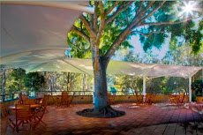
What can be seen from the opposite bank is the frame of the shade sails that were a feature of the cafe. From a distance it's hard to make out how our iconic tree survived. It seems like there's a huge pile of debris in the area.
What I think was the bird hide is just some sticks and very little else.
Some official estimates put the time frame of the water dropping enough to access the park as the middle of next week.
In the meantime, it just a waiting game.
Showing posts with label Brisbane River flood graph. Show all posts
Monday, January 17, 2011
Monday, January 10, 2011
Packed and Ready to Go
Called in by the local authorities and SES late last night to prepare the cafe for a new flood peak.
Word is that the flood waters from Lockyer Creeek - near Gatton will combine with increased releases from Wivenhoe dam - and hit around 13m at Colleges Crossing.
Water is not far from the cafe wall with the river level tonight at 10.21m.
The SES joined staff in packing and preparing the cafe for evacuation.
We were also advised that the only alternate route to the Colleges Crossing bridge - the Mt Crosby weir is closed. The river level at the weir is 12.69m.
That means for anyone living in this area - a 50km round trip.
Which local politician said recently that no money should be spent on Colleges Crossing? Good luck with your future career.
If the flood levels do reach the heights predicted - the cafe and the caretakers house will be shifted to higher ground.
It is one of the unique features of the Colleges by the River cafe that it was designed for just such an emergency.
Tomorrow (Monday) a decision will be made whether to shift the cafe to higher ground on the back of a flatbed truck.
But, preparing for that meant that staff and SES people worked until the early hours packing everything up.
The caretakers residence was also prepared for evacuation - it may also be transported out of the park.
Work teams will be back on site early in the morning to access the situation.
Thanks to everyone who helped with the work at the cafe throughout the night.
Word is that the flood waters from Lockyer Creeek - near Gatton will combine with increased releases from Wivenhoe dam - and hit around 13m at Colleges Crossing.
Water is not far from the cafe wall with the river level tonight at 10.21m.
The SES joined staff in packing and preparing the cafe for evacuation.
We were also advised that the only alternate route to the Colleges Crossing bridge - the Mt Crosby weir is closed. The river level at the weir is 12.69m.
That means for anyone living in this area - a 50km round trip.
Which local politician said recently that no money should be spent on Colleges Crossing? Good luck with your future career.
If the flood levels do reach the heights predicted - the cafe and the caretakers house will be shifted to higher ground.
It is one of the unique features of the Colleges by the River cafe that it was designed for just such an emergency.
Tomorrow (Monday) a decision will be made whether to shift the cafe to higher ground on the back of a flatbed truck.
But, preparing for that meant that staff and SES people worked until the early hours packing everything up.
The caretakers residence was also prepared for evacuation - it may also be transported out of the park.
Work teams will be back on site early in the morning to access the situation.
Thanks to everyone who helped with the work at the cafe throughout the night.
Thursday, December 30, 2010
It's a beautiful morning...
A beautiful summer day - and the Brisbane River is still climbing at the Colleges Crossing Recreation Reserve. The river is getting close to 9m. Check the river height tracking program by clicking on the headline.
At the Mt Crosby weir the river has risen over 11m. Its going to be a interesting couple of days. Mt Crosby road is of course closed, and the Colleges Crossing bridge is still drowning under the raging river. When this flood is over - there will need to be plenty of cleaning up in the park.
There are still plenty of spectators lining the road down to the park, but the park is closed to vehicles.
The population of the park has increased by one - with the only residents Grant and Megan proud parents of another baby girl. Congratulations.
At the Mt Crosby weir the river has risen over 11m. Its going to be a interesting couple of days. Mt Crosby road is of course closed, and the Colleges Crossing bridge is still drowning under the raging river. When this flood is over - there will need to be plenty of cleaning up in the park.
There are still plenty of spectators lining the road down to the park, but the park is closed to vehicles.
The population of the park has increased by one - with the only residents Grant and Megan proud parents of another baby girl. Congratulations.
Subscribe to:
Posts (Atom)