Showing posts with label Karana Downs. Show all posts

Wednesday, January 19, 2011

Park Devastated

The water has dropped in the Brisbane River at Colleges Crossing with the gates closed at Wivenhoe.
The river height monitor at the Mt Crosby weir is not registering at the moment - but one would expect that the roadway would be exposed.
Word is that there is a lot of damage on the approaches to the bridge. At Colleges Crossing this afternoon the bridge was still under water, and the roads are covered in debris and silt.


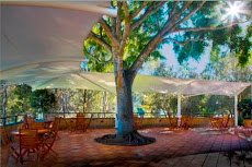
From the Karana Downs side of the river the damage to the park on the opposite bank is obvious. This has been enormous destruction. Aerial shots from nearmap.com taken last Friday showed that the tree that was a major feature of the cafe had been uprooted. Today the scene in the park was akin to the aftermath of a cyclone.


What appears to be the bird hide has been dumped into the middle of the river.


As the river keeps falling, and when Mt Crosby Road is open it will be possible to have a close-up inspection of the disaster. It doesn't look pretty, and won't be fixed quickly. So many trees have been destroyed, and it appears that a lot of the park has been reshaped by the raging torrent over the past two weeks.


This afternoon, a wild storm raged through the area, something that is becoming a bit repetitive of late.
There's also a warning of a flood (king) tide expected on Friday in Brisbane. The river is still tidal at Colleges Crossing, and it will be interesting to see if that big tide on Friday will have much impact.

Monday, January 17, 2011

The river is wide

Checked out the river at Karana Downs where Mt Crosby Road winds over the bridge at Colleges Crossing. While the flood threat passed last week for most of Brisbane, here at Colleges Crossing it hasn't dropped much.
Wivenhoe dam is at 123% and dropping, discharging around 299,000 megalitres a day. The gates closing sequence is underway and at this stage the gates are expected to be closed by mid week.
The river is still hundreds of metres wide at the crossing, and we'll have to wait until the water subsides to get any idea how much devastation there is in the park.


The Mt Crosby weir is at 16.2m and rising at the moment, despite the gate shutdown sequence at the dam.
What can be seen from the opposite bank is the frame of the shade sails that were a feature of the cafe. From a distance it's hard to make out how our iconic tree survived. It seems like there's a huge pile of debris in the area.
What I think was the bird hide is just some sticks and very little else.


Some official estimates put the time frame of the water dropping enough to access the park as the middle of next week.
In the meantime, it just a waiting game.

Saturday, January 15, 2011

Survivor - Karana Downs

With power restored last night (8pm) - life returned to normal after a week in which we had been cut off from the outside world. No electricity, no phone, no food, no petrol, and cars packed to the roof ready for evacuation. The Mt Crosby weir was drowned under 26 metres of flood waters - Colleges Crossing continued to the cut - and the only road east to Brisbane was also under water.
The authorities finally realised that there were people living in the exotic far-flung suburbs of Karana Downs, Mt Crosby and Bellbowrie, late Thursday afternoon - despite the fact that these areas were the first to be inundated by the huge flood. By the way - there's about 25,000 people living in this area. A lot to lose in disaster planning.

The Brisbane River level at Mt Crosby today is still running at near 17 metres.
The river at Colleges Crossing is still raging on a wide front. The Navy is running emergency boats across the water from Karana Downs to the Chuwar side.


The above picture is taken from the Karana Downs side of the road leading to the bridge across Colleges Crossing. Remember what it looked like - it has been underwater for the best part of three months.

The devastation of Colleges Crossing looks complete. There were reports that the iconic fig tree at the cafe had been uprooted. Observing the scene from the Karana Downs side yesterday there was nothing to see but a sea of water. What could be seen was the awnings that surrounded the cafe laying crumpled up against the road up the hill. The peak flood level reached halfway up the hill.
If the tree and awnings have been swept away, it is fair to assume that the entire deck that the cafe was on has been devastated.


The above photo is of what used to be the Colleges Crossing park.

Seqwater yesterday increased the releases from Wivenhoe dam to 301,000 megalitres - so the flooding through the area will continue for sometime. It will take a while the the waters to subside - so that the full extent of the damage to the park can be assessed.
But, it would be fair to say that the cafe will be closed for a long time.
Today, it starting raining, and the cycle starts over again - there are cyclones dawdling around off the coast.